LES CHEMINS DE LA LIBERTÉ : DE SALÉCHAN À LES (ESPAGNE)
Foot
Steps
- Step 1
- From Saléchan–Siradan station, walk through the first narrow streets and head towards the wooded valley in the direction of Estenos. After a downhill stretch along a cobbled path, walk along the upper edge of the village and cross the stream near its waterfall.
- Step 2
- The route then joins the A-road. Follow it with great care for about 1 km, until you reach the Pyrénées’Hô area, then head towards Lake Cierp. Walk along the lake, cross the small wood and make your way to Cierp via the side streets. The village shops are a good place to stock up on supplies before the climb.
- Step 3
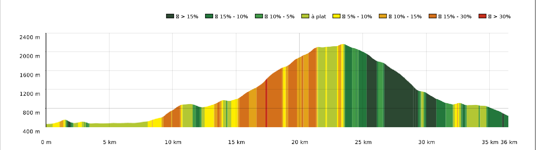
- Continue towards Marignac and the Place des Évadés, where the ‘Chemin pédagogique de la Liberté’ (Freedom Educational Trail) begins. Head up the road through the woodland until you reach the junction with the GR86. The climb alternates between steeper sections and forest tracks as you head towards the Soueste Chapel. Along the way, a viewing point offers a stunning view of the Pic du Gar.
- Step 4
- The Soueste Chapel is an ideal spot for a lunch break. Situated at a vantage point, it offers a beautiful panoramic view and has picnic tables and a fountain where you can fill up with water.
- Step 5
- From the chapel, continue uphill along a track near a barn, then make your way to the Tréboucas plateau, at an altitude of 1,000 metres. The plateau offers a stunning view.
- Step 6
- The route then follows several narrow paths and logging tracks which join a forest track. Continue along the stony track until you reach the junction signposting the Planet hut. A short round trip takes you to the Plagnette hut, which is a strategic point for water management: it is the last water source before a long stretch of the route.
- Step 7
- Return to the crossroads and head back towards the ridges, the Pic de Burat and the Planet hut. A steep path climbs straight up the slope, winding through woods and glades. It’s a sustained climb, but gaps in the vegetation gradually reveal stunning views of the 3,000-metre-plus peaks of the Luchon region, notably the Maladeta massif and Pic d’Aneto in the background.
- Step 8
- Carry on to Planet’s hut, which is the recommended stop-off point for this first day.
- Step 9
- From Planet’s hut, continue along the hillside beneath the Mail de la Pique towards the Pic du Maupas. The path crosses a short rocky section, then climbs more steeply towards the Port de Burat area and the Col d’Escloudaou. Keep an eye out for the trail in the open sections and on the ridges.
- Step 10
- The route then joins the GR10 and heads towards the Pic de Bacanère, the highest point of the crossing. From there, head down the ridge towards the Col des Taons de Bacanère. This stretch marks the entrance to the Val d’Aran and offers sweeping views across both sides of the Pyrenees.
- Step 11
- On the Spanish side, gradually make your way down from the higher ground through the pastures. The Vaquèr de Saplan hut serves as a landmark on the descent.
- Step 12
- A long descent continues towards Bausen. The landscape gradually changes: the mountain pastures give way to wooded areas, then to the outskirts of this Aranese village with its stone and slate houses.
- Step 13
- The descent can be gruelling after all those kilometres spent on the hills.
- Step 14
- From Bausen, follow the signposted route towards Les. The route passes through the area around the Vernet viewpoint before reaching the valley floor and the village of Les.
Itineraire
LES CHEMINS DE LA LIBERTÉ : DE SALÉCHAN À LES (ESPAGNE)
Gare de Saléchan
65370 SALECHAN
65370 SALECHAN